


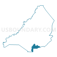
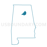
Pine Mountain, Blount County, Alabama
About
Outline

Summary
| Unique Area Identifier | 521248 |
| Name | Pine Mountain |
| County | Blount County |
| State | Alabama |
| Area (square miles) | 14.39 |
| Land Area (square miles) | 13.99 |
| Water Area (square miles) | 0.40 |
| % of Land Area | 97.22 |
| % of Water Area | 2.78 |
| Latitude of the Internal Point | 33.81580860 |
| Longtitude of the Internal Point | -86.54861810 |
Maps

Graphs
Select a template below for downloading or customizing gragh for Pine Mountain, Blount County, Alabama


Neighbors
Neighoring Voting District (by Name) Neighboring Voting District on the Map
- Allgood, Blount County, AL
- Clay Community Center, Jefferson County, AL
- Holly Springs, Blount County, AL
- Palmerdale United Methodist Church, Jefferson County, AL
- Remlap, Blount County, AL
- Springville Me C Voting District, St. Clair County, AL
Top 10 Neighboring County Subdivision (by Population) Neighboring County Subdivision on the Map
- Springville CCD, St. Clair County, AL (20,727)
- Oneonta CCD, Blount County, AL (14,908)
- Clay CCD, Jefferson County, AL (13,695)
- Locust Fork CCD, Blount County, AL (8,731)
- Palmerdale CCD, Jefferson County, AL (5,686)
Top 10 Neighboring Place (by Population) Neighboring Place on the Map
Top 10 Neighboring Unified School District (by Population) Neighboring Unified School District on the Map
- Jefferson County School District, AL (230,679)
- St. Clair County School District, AL (53,540)
- Blount County School District, AL (50,755)
Top 10 Neighboring State Legislative District Lower Chamber (by Population) Neighboring State Legislative District Lower Chamber on the Map
- State House District 50, AL (55,378)
- State House District 34, AL (50,560)
- State House District 51, AL (48,552)
Top 10 Neighboring State Legislative District Upper Chamber (by Population) Neighboring State Legislative District Upper Chamber on the Map
Top 10 Neighboring 111th Congressional District (by Population) Neighboring 111th Congressional District on the Map
Top 10 Neighboring Census Tract (by Population) Neighboring Census Tract on the Map
- Census Tract 405.01, St. Clair County, AL (11,002)
- Census Tract 507, Blount County, AL (8,731)
- Census Tract 501.01, Blount County, AL (7,858)
- Census Tract 112.06, Jefferson County, AL (5,686)
- Census Tract 111.10, Jefferson County, AL (5,677)